


2015-09-12 Visite de Le Chatelard

holtzv
User GUIDE
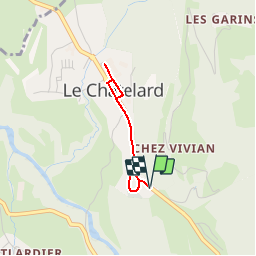

Length
2.1 km

Max alt
777 m

Uphill gradient
36 m
Km-Effort
2.6 km

Min alt
739 m

Downhill gradient
35 m
Boucle
Yes
Creation date :
2015-09-12 00:00:00.0
Updated on :
2015-09-12 00:00:00.0
38m
Difficulty : Very easy

FREE GPS app for hiking
 SityTrail
IGN / Geographical institutes
SityTrail Plus
The world is yours!
About
Trail Walking of 2.1 km to be discovered at Auvergne-Rhône-Alpes, Savoy, Le Châtelard. This trail is proposed by holtzv.
Positioning
Country:
France
Region :
Auvergne-Rhône-Alpes
Department/Province :
Savoy
Municipality :
Le Châtelard
Location:
Unknown
Start:(Dec)
Start:(UTM)
277172 ; 5062605 (32T) N.
Comments